Expanding on last week’s discussion and thinking about a possible final project, I’ve been searching for maps of my hometown, Renovo, PA, to see what kind of information I can glean from them. I was able to find digitized Sanborn maps from 1887, 1892, 1897, and 1911 from Penn State’s Digital Collections and two more from 1904 and 1941 that are cataloged at the Library of Congress. As we saw last week in class, these Sanborn maps contain a ton of information about businesses, homes, and street grids, acting as snapshots in time.
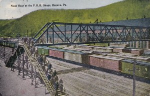
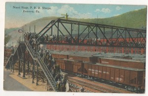
Just by viewing the 1911 map, I can see that there are more businesses along Erie Avenue than any other street, making them visible to the train passengers that passed through or stopped in town. You can also see on sheet 3 the location of the railroad’s footbridge that allowed workers to cross the tracks to reach the repair shops.
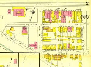
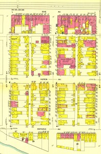
Erie Avenue was the heart of the business district, as stores, grocers, banks, and restaurants catered to the employees of the Philadelphia & Erie Railroad, which later became the Pennsylvania Railroad. Incorporated in 1866, the borough of Renovo (Latin for renew) was established to maintain and repair the trains that traveled from Philadelphia and Erie and subsequently a population grew around the railroad for just over a century until 1968. By the time that I was born in the early 1980s, the bustling Renovo that once hummed with a large workforce was largely gone.
As the railroad left Renovo, the population dwindled, businesses closed, and many of the buildings along Erie Avenue collapsed or burnt down. The shops that once employed thousands of workers across the tracks were also torn down over time after being re-used for a variety of other purposes.
As a kid, I never understood why “Back Street, ”which is what we called Erie Avenue, had the majority of businesses that was left in town, when Huron Avenue was the main thoroughfare through the town (PA Route 120). Looking at this 1911 map, though, I see what all the fuss was about. If I were a smart business owner in the early 1900s, I would surely want to have my storefront face towards the direction of the rail yards. It’s interesting that as the rail industry left town, more travelers had already switched to automobiles for their transportation needs. The highway that cuts through town bypasses Erie Avenue altogether.
While the borough of Renovo has said goodbye to the rail industry, a single track that still remains parallels Erie Avenue while all but one of the original repair shops have been erased. Currently, the town is undertaking a revitalization effort to restore the historical value of Renovo and a brand new energy plant is slated to be built in the next few years. As the sesquicentennial anniversary of the town’s incorporation approaches next year, I’m finding its history even more fascinating. I’m hoping I can use maps to uncover some historical aspect of Renovo that may have gone unnoticed and perhaps contribute to the town’s revitalization effort by highlighting its rich industrial history.
This week, I’ve commented on Danielle’s blog about tackling research questions and arguments.
I think you’re on the right track. It might be interesting to do an analysis of the businesses surrounding the area to see if there’s the same segregation of types of businesses and ethnicities that we saw on the Cheyenne map in class.
Interesting stuff. Thanks for your work.
Any interest in seeing an accurate map of the buildings and tracks?